As I was reading a book review the other day, I was reminded that, in my eagerness to discuss the lesser-known borderlands of Western Europe in my last post, I neglected a very interesting borderland region in Germany: the area to the south and east of Dresden. Located in the far eastern corner of Germany near the Czech and Polish borders, Dresden is on the edge of several borderlands, as the map below indicates.
Before World War I, the political geography of this region looked quite different than it does today: to the south of Dresden was the border with the Habsburg Empire, to the east were the German-ruled regions of Lower and Upper Silesia, and beyond that was Russian-ruled Poland. After World War I, the borders changed somewhat: the border with the Habsburg Empire became the border with independent Czechoslovakia, and part of Upper Silesia was assigned to Poland, but the rest of Silesia (including the part nearest Dresden) remained German territory.
Until 1945, however, nothing in this borderland region was as straightforward as this description would imply. Lower and Upper Silesia, ruled by Prussia (later Germany) since the eighteenth century, were both multilingual, multiethnic regions, inhabited by Germans, Poles, and the nationally indifferent, those people who didn’t consider themselves to be in either national group. Saxony, of which Dresden is the capital, bordered the Sudetenland in the Habsburg Empire, but that region – despite Hitler’s later claims to it as “German” territory – was inhabited by both Germans, Czechs, and, again, the nationally indifferent.
Only after World War II did this region become less of a borderland and more of a region with borders. Lower and Upper Silesia were assigned to the postwar Polish state, which, seeking to eliminate national minorities and create an ethnically and nationally homogeneous nation-state, expelled the German population of those regions. Czechoslovakia, once again in possession of the Sudetenland, expelled the German population of that region. From about 1948 onward to the present, instead of Germans and Czechs living in Czechoslovakia, and Germans and Poles living in Germany, Germans have lived in Germany, Czechs in Czechoslovakia (later the Czech Republic), and Poles in Poland.
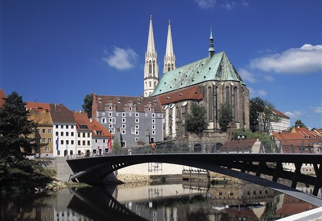
Since the entry of Poland and the Czech Republic into the European Union, some things have begun to change in this former borderland, especially in terms of mobility. Görlitz, a city quite literally on the German-Polish border, is a prime example of this. Before 1945, Görlitz straddled the Neisse River. After the Potsdam Conference, which set the new German-Polish border at a line drawn down the Oder and Neisse rivers, Görlitz was divided into Görlitz, Germany, and Zgorzelec, Poland (see map below).
In the last decade or so, however, after Poland joined the European Union, connections between the two cities (and countries) have greatly increased. When I visited Görlitz in 2010, pedestrians such as myself were able to walk across a pedestrian bridge that spans the Neisse, connecting Germany to Poland.
When I visited Dresden this summer as part of a research trip, I was interested (and happy) to find signs that transnational cooperation and mobility in this former borderland region has continued to increase. One day, while riding the tram in Dresden (which is equipped with TV monitors that deliver the news to commuters), I learned that there are plans to introduce an express train connection between Dresden and Ústí nad Labem, a city in the northern Czech Republic (part of the former Sudetenland), making it easier for businesspeople, other travelers, and tourists alike to move between Germany and the Czech Republic.

Speaking of tourism, I also saw several posters around Dresden advertising the Polish city of Wroclaw, formerly the German city of Breslau, as an easily accessible (and fun!) destination, just a short (and affordable) train ride from Dresden. In this attempt to entice Germans to visit Wroclaw, there was an interesting sign that not all linguistic traces of the region’s former borderland status have disappeared. While Wroclaw was the name most prominently featured on the posters, the city was also referred to at least once by its former German name of Breslau. Were the posters, perhaps, invoking Wroclaw’s German heritage as a tactic to draw Germans in: come to Wroclaw, see where your relatives (maybe) used to live? Hard to tell – I still can’t decide how I interpret it.
What will continue to develop in this former borderland region is anyone’s guess. My hope is that the current moves toward greater mobility and interconnections in the region will continue to be built upon in the future. However, with the rise of populist and nationalist parties and governments in Europe (including in Poland), there could quite conceivably be movement in the opposite direction, another reminder that borders and border regions are both ever-changing and ever-affected by politics.
Suggested reading:
- On the Bohemian Lands: Tara Zahra, Kidnapped Souls: National Indifference and the Battle for Children in the Bohemian Lands, 1900-1948
- On the remaking of Poland after 1945: Hugo Service, Germans to Poles: Communism, Nationalism and Ethnic Cleansing after the Second World War
- On the Saxon-Bohemian borderland: Caitlin Murdock, Changing Places: Society, Culture, and Territory in the Saxon-Bohemian Borderlands, 1870-1946
- On the expulsion of Germans and remaking of the Czechoslovak borderlands: Eagle Glassheim, Cleansing the Czechoslovak Borderlands: Migration, Environment, and Health in the Former Sudetenland


Leave a comment